Saturday, March 28, 2009

Rees Dart Tracks and Cascade Saddle

These photos are much more pleasant than that toe one, I promise! (sorry)

Link to the Gallery

Some samples...

From Rees Dart Track
Rees valley


From Rees Dart Track
Dart Glacier


From Rees Dart Track
A view from Cascade Saddle. Mount Aspiring is the snowy peak on the left.

"My toes felt just like two balloons..."

My entire big toenails are going to fall off eventually, and they hurt when walking and standing a bit... but the worst is over, because both my toes looked like this by the fourth day on the Rees Dart track, and even bigger on the fifth (last day):


Giant blisters formed under my nails, lifting them up, and stretching the skin around them like big balloons. Fortunately they weren't bloody, and the nails stayed attached. Walking in my boots was manageable (thankfully), but my sandals just couldn't fit my grossly enlarged toes.

What happened?? The first day of the track had several stream fords resulting in sopping wet feet/socks/boots, and I was wearing 2 layers of socks for comfort. Things expanded, there was less room for poor little toes, and the terrain was pretty technical in places. The toenails were already tender at the end of the first day. Second day was dry but I still had 2 layers of socks on (didn't know what I was getting myself into) and the terrain was much more technical with plenty of downhill. End of 3rd day, there was some swelling under the nails, enough to make walking around painful (especially in my sandals which cover the big toe). After 4th day they ballooned (see picture).

It's much better now though. The day after we got off the hike (yesterday), I went to the medical centre at Queenstown to get it looked at. The doctor offered to drain it – purely symptomatic – I said yes please! It was a very technical procedure: she heated up the end of a paper clip over a flame until red hot, then put it through the middle of the nail. Squirt! Ahh, much better. The student nurse then did the other one. Easy enough... now I know how it's done. I could do it again myself if I had to! Things are still kind of sore of course, but I'm not hobbling around anymore, and I should be good for tomorrow's day of hiking up Fox Glacier on NZ's West Coast (guided, of course), and hopefully good for the next tramp.


UPDATE: since writing this post things aren't as great as I thought. some skin broke around the front of the toe, so it's partially open now. boooo. hopefully the toenail stays on during some upcoming hiking, but... I'm having my doubts

Rees Dart Tramp

Once again, it has been a week without us posting. I would like to take this opportunity to apologize to everyone who is so enthralled with our adventures that they are checking every day, but end up disappointed 6 days a week. Although the back country huts in New Zealand have running water, they unfortunately do not have wireless.

The Rees-Dart hike was awesome in many ways. We had sunny weather for most of the hike and there was no rain. The company in the huts was great and we met lots of cool people from pretty much all over the world. The scenery was also incredible.

The hike started with a hike up the Rees valley. There were great views of the surrounding peaks for much of the first day. On the second day, we climbed over the Rees saddle into the Dart valley. The view from the saddle was awesome and we were able to climb a bit higher to get a 360 degree panorama of the area. On the third day we did a side trip to the Cascade Saddle and got probably the best view we have ever had. It was a pretty difficult climb and we were scrambling in places, but it was definitely worth the effort. Behind us was the massive Dart Glacier and in front of us was the massive, snowy Mt. Aspiring, the mountain that the national park we were hiking in is named after. The other side of the saddle dropped 600 feet into a beautiful valley and it was pretty crazy to sit on the edge of the cliff and look out on the valley below. The pictures from the saddle look like they are taken from a helicopter. It was a pretty hard to walk down from the saddle, and not just because the trail was so steep. The last two days were spent walking out through the Dart valley along the beautiful Dart river. I think that the pictures speak a lot louder than words for this hike.

I would just like to mention a few other things about this hike:

1. Bear Army: For those people who do not know what Bear Army is, it is basically an organization of people who like to hike slow, take in the scenery, and enjoy eating honey and berries (and chocolate). We met the couple who actually started Bear Army on this trip. Seriously. They were waaayyy later than everyone else getting to a hut one night because they stopped to take a nap in the sun. And they admitted that they have eaten a 250g chocolate bar in a day. They were pretty awesome.

2.Quinoa: (pronounced keen-wa): It is a grain from South America that is really good. It cooks like rice but has more flavor. It is also a contains all of the essential amino acids, unlike rice. We ate it every day on this trip and enjoyed it. It gets our stamp of approval.

3.Superfine merino: I bought a new shirt made of superfine merino wool, and it is awesome. It is as soft as cotton, but wicks away sweat. It is also not too hot or itchy like wool can be. It also did not stink after five days of sweating (And I mean really sweating. One day I drank 3L of water sweating.). Also, I think that it is pretty fashionable (it is the green shirt in the pictures). We actually went back to the store to buy more superfine merino garments after the hike.
After the hike, we had a Fergburger (a very large and delicious burger in Queenstown), a beer, and ice cream.

We are now in Franz Josef on the West Coast. We have taken it pretty easy for two days and tomorrow we are shelling out some cash to do a glacier walk. The glaciers are pretty unique here because the toes end in rainforest and we are only a few kilometers from the coast.

Well, that is about it for my update. I hope you enjoy Jay's pictures from the hike and the saga of his toes.

Friday, March 20, 2009

More photos

Got some more photos uploaded.

1. Dunedin photo gallery
From Dunedin


2. Otago Central Rail Trail photo gallery
From Otago Central Rail Trail


3. Wanaka photo gallery
From Wanaka

Rail Trail and Wanaka

Hey hey hey,

Sorry it has been so long since our last post. We have been too busy/lazy (there is such a fine line between busy and lazy and we walk it every day).

Anyways, since we last spoke we have done some pretty cool things. I will start from the beginning and work my way to the present.

About a week ago, we started a four day bike trip on the Otago Central Rail Trail. The trail is a former rail line that was taken out when it became legal to transport produce and wool by road. (Previously, the NZ government banned transport of produce by truck more than 75 km in order to protect the railway). The trail has been open for nine years and is really popular, especially with Kiwis from the north island.

The bike trip was great! The advantage to biking on a rail trail rather than on a road are that the rail trail never has more than a 1/50 slope, so it is never steep. Also, there is no traffic buzzing by all day. Besides the enjoyable biking, the scenery was amazing. It varied between lush farmland to rocky hillsides with mountains in the background. The photos really do not do it justice. We also had fantastic weather, it was 25 degrees all four days with no clouds and no wind.
Besides the great trail and scenery, the little towns that we passed through and stayed in were awesome. The popularity of the rail trail has revived a lot of the small towns in the area and a lot of residents have opened up bed and breakfasts along the trail. On the third night, we stayed in a store building that was built in the late 19th century from mud bricks. It was converted to a bed and breakfast last winter and the owners were really careful to maintain the bricks and the store front. The renovation turned out really well and it was a beautiful place to stay.

The hospitality that we experienced along the trail was also amazing. Everyone was very friendly and helpful and we had a lot of nice conversations with a lot of the locals and people visiting from the north island. We were also impressed with the meals that we had along the trail. We definitely did not expect the high quality dining that we got when we walked into the small town taverns.

Despite the sore legs and butts, the rail trail was definitely an awesome experience.

After the rail trail, we headed west to Wanaka, a small town north west of Queenstown. Wanaka is another town set on a picturesque lake surrounded by mountains. On our first day here, we went to Stuart Landsborough's Puzzling World, an attraction just outside of town. Puzzling World is probably one of the coolest places I have been to (because I am a huge nerd). They have some really cool exhibits, including a room with holograms on display, a room with famous people's faces that follow you as you walk around the room, rooms that play with perspective, and a giant, two story, modern maze that takes about an hour to complete. The also have a cafe where you can sit and play with an assortment of puzzles. Very cool!

Yesterday, we climbed Mt. Roy, a mountain just outside of Wanaka. It was about a three hour climb and a two hour descent. We had good weather and had great views of the surrounding area from the top of the mountain.

Today we are both a little sore and we are just taking it easy. We are going to see a movie later on at Paradiso Cinema, a cinema in town that we have heard a lot about. Each movie starts with an introduction from the owner and there is a cafe inside the theatre where you can get meals at intermission – it is supposed to be very cool.

In a day or two (when we feel recovered enough) we are going to head back down to the Queenstown area to start another tramp in the Rees and Dart valleys. The tramp is pretty highly recommended, especially by locals, so we are looking forward to that.

We hope that you all are well and not too cold (I hear that the weather is warming up),

Erin

Friday, March 13, 2009

Invercargill -> Dunedin

Hello everybody,

Greetings from Dunedin!

It has been a little while since we have posted because the Internet in the hostel was not working, so I guess I have a lot of catching up to do.

The first day of our Catlins tour was really beautiful. We headed south from Invercargill to Bluff and did a short walk to see a ship graveyard (where they parked ships to rot in the 1800s). After lunch in Bluff, we headed east along the coast. There were great views of the coast and the farmland along the way including this beautiful beach at Curio Bay:


Also at Curio Bay, we ran into this guy (or girl):


This is the rare yellow-eyed penguin. There are only 750 pairs in New Zealand. He was really cute hopping along the rocks.

After Curio Bay, we spent the night camping at a Department of Conservation campsite along the coast. The campsite was really beautiful because we had great views of the ocean and cliffs. Here is a glamour shot of our car at the beach during the moon rise:


The next morning we planned to do more sight-seeing along the coast, but the weather was horrendous. So we pulled into a backpackers (what the Kiwis call a hostel) in Owaka. It was the coolest hostel I have ever been to. Its décor definitely made it seem more like a bed and breakfast. We were staying in the “Bee Room” of a little three bedroom cottage. The room was decorated with little bees all over the wall and was very cute and homey. We spend the day hiding from the weather at the backpackers there.

We headed to Dunedin the next day. We have spent the last three days seeing the sights here, including a tour of a Cadbury Chocolate Factory and Speights Brewery. Both tours included lots of free samples!

Tomorrow we are starting a four-day bike trip of the Otago Rail Trail. It is a 150km bike trail that was created on a former railway, so it stops in several towns along the way. The weather forecast looks good, so we are both really excited.

Until next time,

Erin

Monday, March 9, 2009

Greetings from Invercargill

Hello folks! We're in Invercargill right now, stopping for a break at New Zealand's southernmost city between doing a one-night hiking trip on the South Coast Track and taking a leisurely drive along the Catlins Coast eastwards to Dunedin.

Our hike on the south coast track was a grueling state of affairs: 7 hours of hiking each way, with just maybe one hour of total beach walking each way, the rest of it was plodding along tiringly through the forest without a view and a good amount of mud. Glad I had my gaiters. The beach walking was nice though, and the destination, Port Craig Hut, is actually the old school house of the old, short-lived Port Craig, a failed lumber settlement, so that was cool I guess. But doing that hike before trying to do the 10-day Northwest Circuit on Stewart Island was a mistake! We need more recovery time now.

But for various reasons we've decided we don't really want to do the NW Circuit anymore. Too long, too hard, and not that many actual views of the ocean, despite walking the outside of the island the whole time. I do not need more viewless forest walking! And not doing this tramp frees up a lot more time on our trip. And not doing the 10-day circuit has basically eliminated our reason for going to Stewart Island entirely... the cost of transport isn't worth the day trip out there...

So we're going to take our time driving along the southeast coast, camping at a couple spots along the way until we get to Dunedin. In Dunedin, we've got the Speight's Brewery tour and Cadbury chocolate factory tour. Around Dunedin there's a penguin colony we'll try to see, too. Erin's keen on doing this multi-day bike tour out of Dunedin along the Otago Rail way. We'll see!

What about Invercargill? It's alright. :) If you check our Invercargill photo album, you'll see a few things we saw here. We went to the Museum and Art Gallery, and then wandered the adjecent Queen's Park, which contained some botanic gardens, rose gardens, a bird aviary. The museum has a section devoted to Burt Munro, the old kiwi bloke featured in the movie The World's Fastest Indian (he was from around here). So cool!

Before setting off towards Dunedin tomorrow, we're gonna stop in at Bluff, just south of Invercargill, which is a maritimey little town. Should be cool. See you folks again in Dunedin.


South Coast Track Photo Album

Invercargill Photo Album

Thursday, March 5, 2009

Milford Track Photos

And here some pictures from the Milford Track.

Link to the gallery.


A patch of glow worms found near our first hut.
From Milford Track

Routeburn Track Photos

Here are some pictures from the Routeburn Track. Ass you can see the clouds finally started to break up for our first time in NZ.

Link to the gallery.


Some highlights:

Driving halfway between Queenstown and Glenorchy, along Lake Wakatipu.
From Routeburn Track


A typical stream crossing
From Routeburn Track


Part of a long traversing of a slope on the Fiordland side of the hike.
From Routeburn Track

Wednesday, March 4, 2009

Routeburn/Milford

Hello to everyone who is still checking this blog after a week of no activity or pictures.

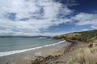
We finished the Milford Track yesterday and now we are relaxing and resting our legs in Te Anau for a few days before heading south. Te Anau is a really pretty town. Like Queenstown, it is surrounded by mountains and is next to a huge lake, but is much more laid back than Queenstown. The weather is beautiful, so it is going to be a nice place to spend a few days.

Now I will back-track and talk about the hikes we just did. I'm sure that Jay's photos will be much more interesting than my description, so I will try and keep the description brief.

Both hikes (the Routeburn Track and the Milford Track) are classified as Great Walks by New Zealand Department of Conservation. This means that the hike is relatively easy and that the huts that you stay in on the walks are really nice. Most hikes in New Zealand have huts along the track that you can sleep and cook in, but these ones have running (cold) water, flush toilets, and gas stoves all provided. Great Walks also have to be booked in advance because they are quite popular and bunk space is limited.

The Routeburn Track is a 3-day, 32km walk. We had great weather for the entire track and we did not have a drop of rain until we finished the walk. I had a pretty bad cold for most of the walk, so it made it pretty challenging. On the first day, we walked along the Route Burn valley and then up to the Routeburn Falls hut. The hut gave an amazing view of the entire valley and the surrounding mountains and was situated right beside a waterfall. It was a very cool place to spend a night.
The majority of the second day was spent above the tree line. We walked up to a mountain pass through a spectacular alpine meadow and then did a side trip to get a better view of the surrounding valleys. Unfortunately, it clouded over before we made it to the top, so we didn't get much of a view. We then walked along a ridge for about 3 hours before descending to our second hut next to the beautiful Mackenzie Lake.
On the third day we climbed back up above the tree line and got amazing views all the way to the Tasman Sea. We then descended to the trailhead and caught a bus back to Queenstown. Just as we reached the trailhead, it began to pour rain, so we were pretty lucky to have such good weather for the track.

The next day we headed to sunny Te Anau to get ready for the Milford Track. My cold was pretty much gone by then, so we were feeling pretty energetic about the next hike.

The Milford track is very famous in New Zealand and very hard to get a place on. Only 40 independent hikers and 50 guided hikers can start the hike every day, so spots on the hike are very sought after.
To get to the hike itself, we had to take a one hour boat ride across Lake Te Anau, which was very pretty. The first day of the hike was very easy and only took about one hour, so we had a lot of time to hang out in the afternoon and evening. During that time, I decided to go for a swim in the Clinton river, which is the clearest and most beautiful river I have ever seen. Unfortunately, the banks are infested with sand flies, which leave very (VERY) itchy bites. So, I had a very refreshing swim but I am now paying for because I am covered in bites. On the first evening of the hike, it started to rain and it didn't stop, which made for a very wet second day. Fortunately for us, the Milford Track is supposedly the most beautiful when it is raining, and I can understand why.
On the second day, we walked through a valley with hundreds of waterfalls on either side. The track alternated between going through lush rain forest and clearings where there were views of the waterfalls along the sides of the cliffs. It was an amazing day.
On the third day, it was still raining quite hard, and, unfortunately, this was the day that we did not want rain. We did a two hour climb to the top of Mackinnon Pass and saw absolutely nothing. It was completely miserable at the top of the pass; it was pouring rain and there was a very strong wind. The hike down the mountain and through the forest was still very beautiful, but we were both pretty disappointed about not getting a view from the pass. On the third day, we also did a side trip to NZ's tallest waterfalls(525 m), the Sutherland Falls.
The third day of the hike was pretty exhausting, it was over very easy terrain, but we had to do 18km and had to be at our boat by 2:00. There were beautiful views, including two more amazing waterfalls, along the way and Milford Sound, where the hike ended, was breathtaking.

So there you have it. A little play-by-play of our last week. I'm sure the pictures are what you are all after, anyways. Those will probably be up tomorrow if you want to check back.

Erin